![Item #64516 HOWE'S MAP OF THE OIL DISTRICT OF PENNSYLVANIA. [caption title]. Henry G. Howe, Civil Engineer.](https://bartlebysbooks.cdn.bibliopolis.com/pictures/64516.jpg?width=768&height=1000&fit=bounds&auto=webp&v=1582571708)
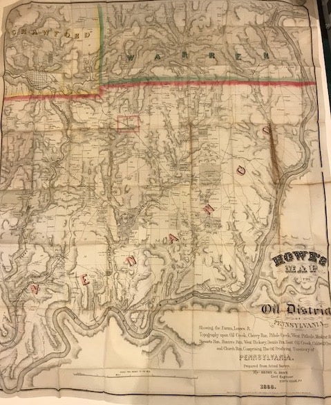
HOWE'S MAP OF THE OIL DISTRICT OF PENNSYLVANIA. [caption title]
[copyrighted Massachusetts: Henry G. Howe], 1866. Large folding pocket map, 94 x 77 cm., on a 96 x 78 cm. sheet, tipped into gilt stamped brown patterned cloth covers. Full title: "Howe's Map of the Oil District of Pennsylvania. Showing the Farms, Leases, & Topography upon Oil Creek, Cherry Run, Pithole Creek, West Pithole, Muskrat Run, Stewarts Run, Hunters Run, West Hickory, Dennis Run, East Oil Creek, Caldwell Creek and Church Run. Comprising The Oil Producing Territory of Pennsylvania. Prepared from Actual Surveys By Henry G. Howe Civil Engineer Titusville, Pa. 1866." The counties of Crawford, Warren, and Venango are outlined in pink, green, and yellow. One of the early boom towns, Pleasantville, in Venango County is outlined in pink; other towns on the map include Titusville, Oil City and Pit Hole City. Individual landowners and farms are marked, as are railroad lines, roads, and creeks. An oil refinery just south of Titusville is noted. A comprehensive map showing the dozens and dozens of companies drilling for oil in the region [Pit Hole Creek & Allegheny River Pet. Co.; Anderson Petroleum; Philips Petroleum; Pittsburgh & Stewarts Run Oil; Morey Farm Oil Co.; Musk Rat Run Pet. Co., etc.] Some browning along one fold line, else a nice, crisp copy.
The first successful commercial oil well in the United States was completed by E.L. Drake near Titusville, Pennsylvania, 28 August 1859. The Streeter collection lists three maps of the Pennsylvania oil region, all published in 1865 [Colton, Hunt, and Townsend & Dale, all smaller than this one, with varying amounts of information given. See Streeter VI, 3920, 3923 & 3925]. The boom spread quickly as evidenced by the vast number of companies drilling by the time Howe produced this map in 1866. No auction records found for the Howes map. Item #64516
Henry G. Howe is listed in the Titusville, Pennsylvania city directory of 1866 as a civil engineer and surveyor, with an office at 6 Fletcher's Block. He was born in Massachusetts in 1839, and marriage records show he returned to the state to marry in 1866. This may explain the Massachusetts copyright for his map, which he evidently self-published. [see: Massachusetts Town Vital Records for Sterling, MA, which lists the marriage of Henry G. Howe, Titusville, PA, Civil Engineer to Josephine Bartlett of Sterling in May 1866]. Howe served in the Civil War with the 15th Massachusetts Vol. Infantry,was wounded at Antietam in 1862 and discharged from the service in 1863. He later lived and worked as a civil engineer in Chicago and Tombstone, Arizona, and died in Bisbee in 1898. According to family lore, he was in Tombstone during the time of the conflict between the Earps and the Clantons which culminated in their gunfight at the OK Corral.
OCLC lists five copies: Yale, Harvard, Penn State, Hagley Museum, and British Lib. Stanford University's David Rumsey Collection adds one more.
Price: $6,500.00