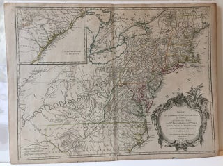
PARTIE DE L'AMERIQUE SEPTENTRIONALE, QUI COMPREND LE COURS DE L'OHIO, LA NLLE. ANGLETERRE, LA NLLE. YORK, LE NEW JERSEY, LA PENSYLVANIE, LE MARYLAND, LA VIRGINIE, LA CAROLINE.
NP [Paris]: np [Robert de Vaugondy], 1755. Map, 18 3/4 x 24 1/2 in., on a 20 x 26 1/2 in. sheet, hand-colored outlines, uncolored cartouche. Inset map of "La Caroline" (coastline) in the upper left corner. Small chip and some short separations along lower margin (one repaired on verso..... More